
Archive Record
Images
Metadata
Title |
Angeles National Forest |
Catalog Number |
2019.028.120 |
Object Name |
Map |
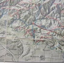
Scope & Content |
Angeles National Forest 1932 >> Grey shaded topographic map creating a three-dimension appearance. >> Map used by Lyn Biddison, with red and blue lines added by the user. Red lines appear to follow watershed boundaries and red line appear to be roads. >> Fabric backing; cut in section to facilitate folding >> Scale" 1.0" = 2 Miles |
Year Range from |
1932 |
Year Range to |
1932 |
Subjects |
Angeles NF |
Search Terms |
Geometronics |
Catalog date |
2019-07-30 |
Extent of Description |
Folded: 8.0" X 10.5"; 25.5" X 38.5" |
Collection |
Biddison, Lynn |
Scale |
1.0" = 2 Miles |
North Latitude |
34 24' |
West Longitude |
118 11' |
Prime meridian |
San Bernardino |